| Desination |
Outline |
City/Town/Village |
# / Map |
|
|
|
|
| TSURUGAJO CASTLE |
a symbol of SAMURAI city built in 1384 |
71N001 |
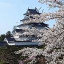 |
The recommended period for cherry blossom viewing is usually around April.
 |
Aizu Wakamatsu(City) |
 |
|
|
|
|
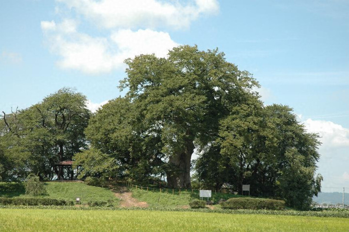
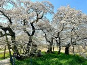
| TAKASE no TAIBOKU |
a large Zelkova tree that is about 500 years old |
71N002 |
 |
This is the site where a castle was planned to be built about 500 years ago.
(external link) |
Aizu Wakamatsu(City) |
|
|
|
|
|
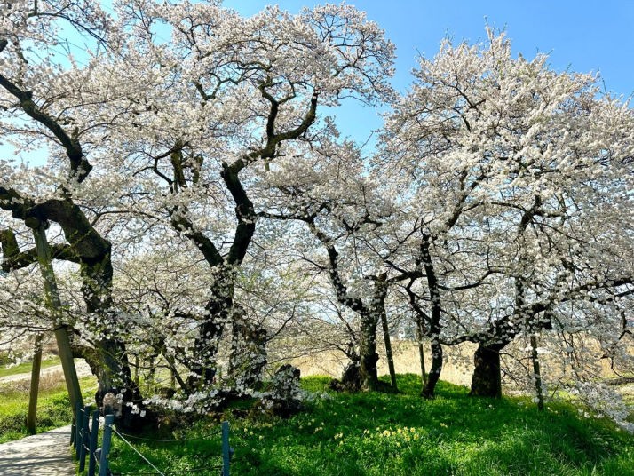
| ISHIBE ZAKURA |
A famous local cherry blossom spot |
71N003 |
 |
A magnificent cherry tree made up of 10 trunks.
The recommended period for cherry blossom viewing is usually around April.
(external link) |
Aizu Wakamatsu(City) |
|
|
|
|
|
| Cherry blossom at NICHU Line |
weeping cherry tree lined street |
71N010 |
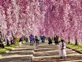 |
The Nichu Line Weeping Cherry Tree Line was developed as a promenade on part of the site of the JR Train Nicchu Line, which was closed in 1984.
Approximately 1,000 weeping cherry trees are planted along a 3-kilometer
stretch from north to south! Within the avenue, you can also see a steam
locomotive that ran there at the time, as well as the so-called "cherry
blossom tunnel" where cherry blossoms seem to be falling from both
sides of the road, making it a great photo spot. The Kitakata Cherry Blossom
Festival is held every year in April when the cherry blossoms are in bloom.
(external link) |
KITAKATA(City) |
|
|
|
|
|
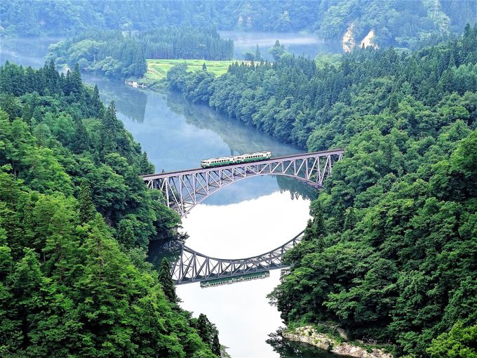
| JR TADAMI Line |
a spectacular view of a train running |
71N014 |
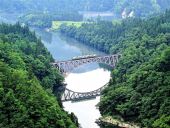 |
The most popular scenic spot is about a 10-minute walk up a mountain path
from the nearest store. There are several other scenic spots nearby.
(external link) |
MISHIMA(Town) |
|
|
|
|
|
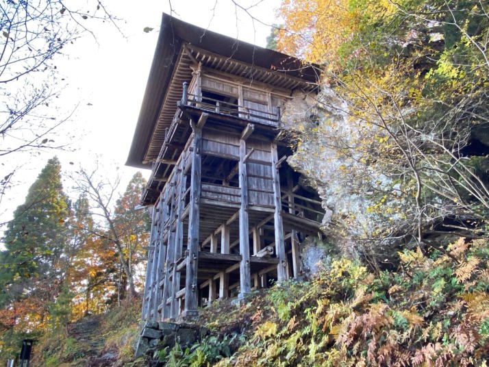
| SAKUDARI KANNONDO |
a hall built on a cliff irenovated in 1358 |
71N018 |
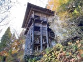 |
A quiet place where few people know. There is a parking lot near the building
(a parking lot at the foot is far away). Admission and parking are both
free. It's possible to get a temple seal at a private house at the foot
of hall (for a fee).
(external link) |
AIZU MISATO(Town) |
 |
|
|
|
|
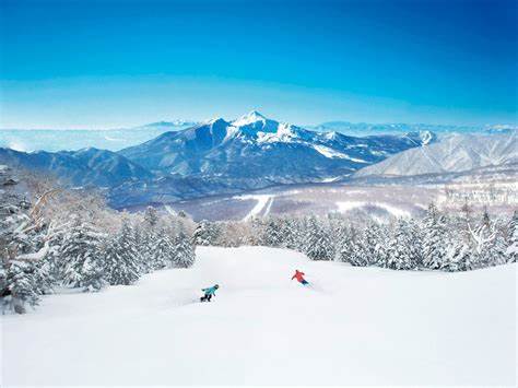
| A top Ski Resort, URABANDAI |
High-quality powder snow that rivals of Hokkaido |
71N019 |
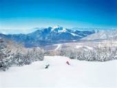 |
A ski resort where you can ski down the slope with a spectacular view of Mt. Bandai right in front of you. There is a free shuttle bus that connects the hotel and the ski resort.
(external link) |
KITA SHIOBARA(Village),
BANDAI(Town) |
|
|
|
|
|
| Lake INAWASHIRO |
the fourth largest lake in Japan |
71N020 |
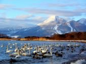 |
Located almost in the center of Fukushima-Ken, it is one of the highest lakes in Japan and belongs to Bandai-Asahi National Park. In the summer, you can enjoy not only swimming but also various water sports such as marine jet skiing.
|
INAWASHIRO(Town),
AIZU WAKAMATSU(City) |
|
|
|
|
|
| CHOSHI no KUCHI |
canyon looks like mouth of a sake bottle |
71N021 |
 |
Located near Niigata Prefecture, this is a particularly famous scenic spot in the Agagawa River gorge. This is where the strangely shaped rocks jut out from both banks. It was named after the fact that the surrounding terrain resembles the narrow neck of Sake Bottle("Choshi" is the Japanese word for sake served in a ceramic sake-bottle). The wide river suddenly narrows to just over 10 meters, and it was said to be the most difficult part of shipping rice, causing great suffering to the people. The way the rapids wash over the rocks is spectacular. It is also famous as a great spot to see autumn leaves, with the best viewing time being from late October to mid-November.
(external link) |
NISHI AIZU(Town) |
|
|
|
|
|
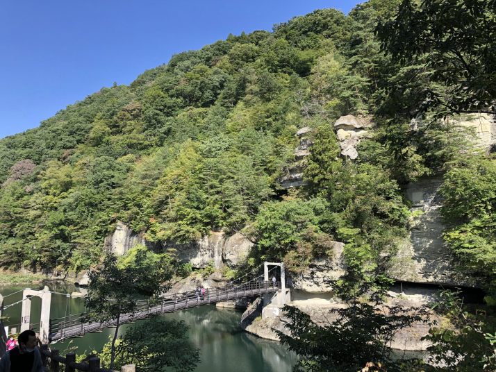
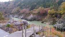
| TO no HETSURI |
towers on the cliff |
|
71N025 |
 |
It has been designated as a national natural monument as a good example
of a deformed river-cut landform. "Hetsuri" is an Aizu dialect
word that means a steep cliff approaching a river. Large, strangely shaped
rocks are lined up over a total length of 200 meters and main rocks have
names. A path has been carved around these rocks, but due to collapse over
time, access is prohibited except around the Butai-iwa rock (stage rock)
where the suspension bridge crosses. The towering strange rocks are made
of tuff from the Neogene layer formed about 28 million to 1 million years
ago. Over the years, the river's water flow, rain and wind have worn down
the rocks, and the soft parts have been eroded, creating a unique shape
like a tower with many layers. Crossing the suspension bridge makes noises
and sways, making it a thrilling experience. From the suspension bridge,
you can enjoy the emerald green water surface and beautiful views.
(external link) |
SHIMOGO(Town) |
|
|
|
|
|
| |
|
|
|
| |
|
|
|
| |
|
|
|
| |
|
|
|